
Keyword
Earth Science | Oceans | Ocean Circulation
5 record(s)
Type of resources
Topics
Keywords
Contact for the resource
Provided by
Formats
Update frequencies
Status
draft
-
In Western Australia (WA), the Environmental Impact Assessment process requires dredging proponents to make scientifically sound predictions of the likely extent, severity, and persistence of environmental impacts of the proposed activity under a spatially defined zoning pattern. This is achieved by using coupled hydrodynamic, wave and sediment transport models in conjunction with water quality (ecological) thresholds for sensitive receptors such as corals, filter feeders, or seagrasses/macroalgae. These predictions guide the scale and scope of associated monitoring programs, providing assistance to proponents as to where to establish environmental monitoring and reference sites. Increasingly, modelling is also being used by dredging programs to forecast a few days in advance, so as to understand the potential consequence of various dredging scenarios and optimize the dredging programs to minimize environmental damage. The overall objective of Project 2/3.4 was to improve the predictive capabilities of sediment dispersion modelling that incorporate dynamic plume and passive plume processes through assessing model sensitivity to key forcing and parameter values, such as met-ocean condition, particle settling velocity distribution, critical shear stress, sediment erosion and deposition, provide frequency and duration of biological stressor fields including suspended sediment concentration, sediment accretion and erosion, and available light; and provide guidance on developing best practice algorithms and parametrizations for dredge plume modelling. Based on the outcome Project 2/3.1, an appropriate modelling suite that includes hydrodynamics, waves, and sediment transport was chosen (Delft3D) to model the far-field passive plume. The model was set up and validated using the bathymetry and baseline data collected as part of the Chevron Australia Wheatstone Project, located near Onslow, Western Australia. The model outputs were assessed against monitoring data from Chevron Australia's Wheatstone Dredging program, including, remote sensing and in-situ data collected in Project 2/3.2. A 20 month hindcast of passive plume dispersal from the dredging project to the furthest extent of the passive plume were compared with the field data and MODIS images (where available). Spatial and temporal variability of plume dispersal under different forcing scenarios and sediment release rates were investigated and reported. This metadata record provides a description of the model input data (and where appropriate its location) and a short description of the software and model set-up. The simulation data files are located in the CSIRO DAP.
-

DEPRECATED: This dataset has been superseded by GBR4_H2p0. It will be decommissioned in April 2024. Results from version 1.85 of the 4 km resolution regional-scale hydrodynamic model of the great Barrier Reef (GBR4). It was forced with BlueLink OceanMAPS data on the open boundaries and Bureau of Meteorology model ACCESS-R for surface atmospheric data. The tide was introduced through 22 constituents derived from the global CSR tide model, and 22 river boundaries incorporated measured stream flow and temperature data from QLD DNRM's gauging stations. This model version was published for reference in the SIEF report from January 2016, but was later discovered to have been forced with incorrect (multiplicative error) rainfall levels, and the 2015 results contain salinity errors. This model configuration and associated results dataset may be referred to as "GBR4_H1p85" according to the eReefs simulation naming protocol.
-

DEPRECATED: This dataset has been superseded by GBR1_H2p0 and it will be decommissioned in April 2024. Results from an early version of the 1km-resolution shelf-scale hydrodynamic model of the Great Barrier Reef (GBR1). This version of the model was forced by version 1.85 of the eReefs GBR 4 km resolution hydrodynamic model, and the results were made available for comparison purposes only. This model configuration and associated results dataset may be referred to as "GBR1_H1p71" according to the eReefs simulation naming protocol.
-
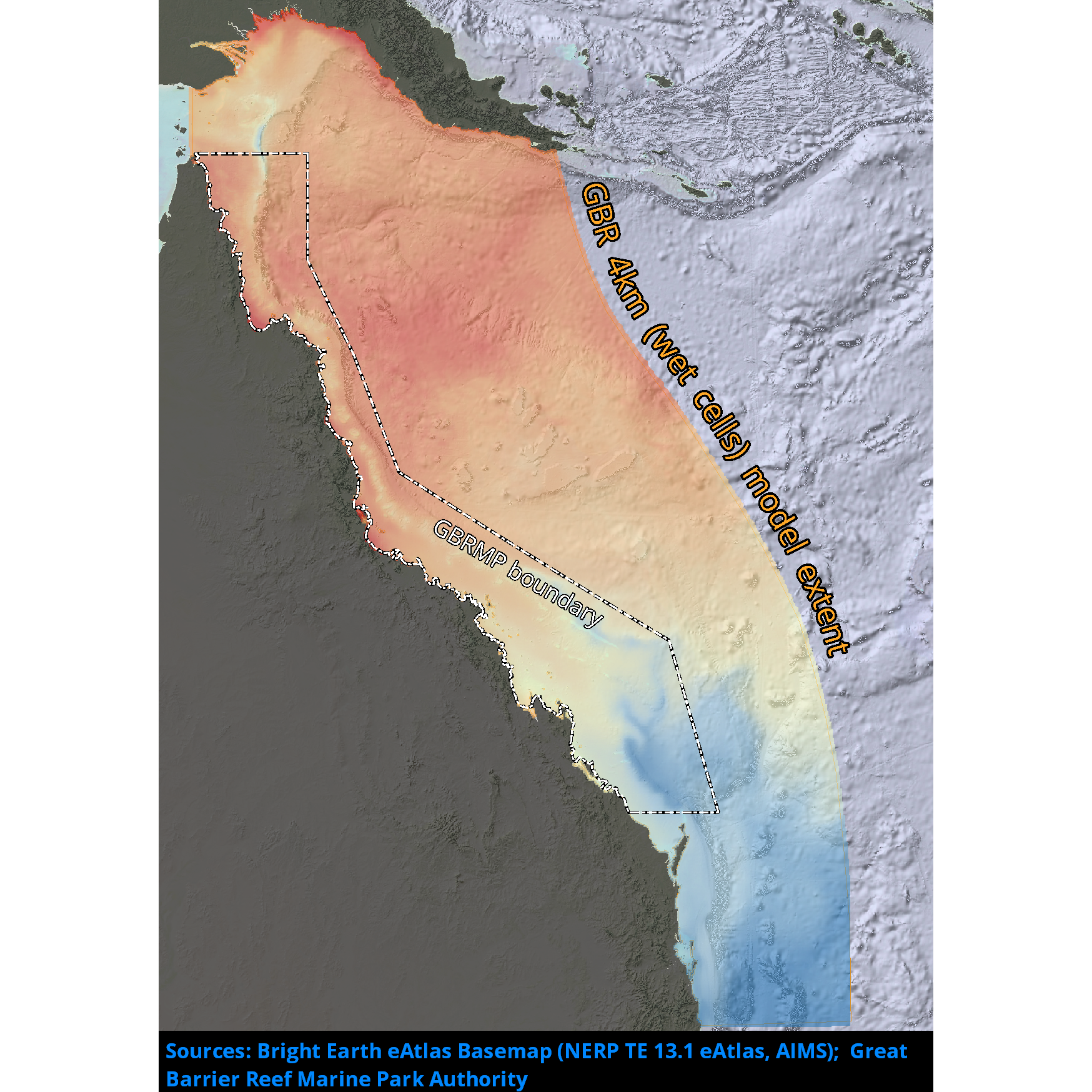
Results from version 2.0 of the 4km-resolution regional-scale hydrodynamic model of the Great Barrier Reef (GBR4). This model is forced with BlueLink Ocean Modelling and Prediction System (OceanMAPS) model results on the ocean boundaries and Bureau of Meteorology ACCESS-R model for surface atmospheric data. The tide is introduced through 22 constituents derived from the global CSR tide model, and the river boundaries incorporate measured stream flow and temperature data from QLD DNRM's gauging stations for 22 rivers, and estimated flows and loads for 49 additional rivers. There are no known forcing problems. This model configuration and associated results dataset may be referred to as "GBR4_H2p0" according to the eReefs simulation naming protocol. The model runs in near-real-time mode, updating daily.
-
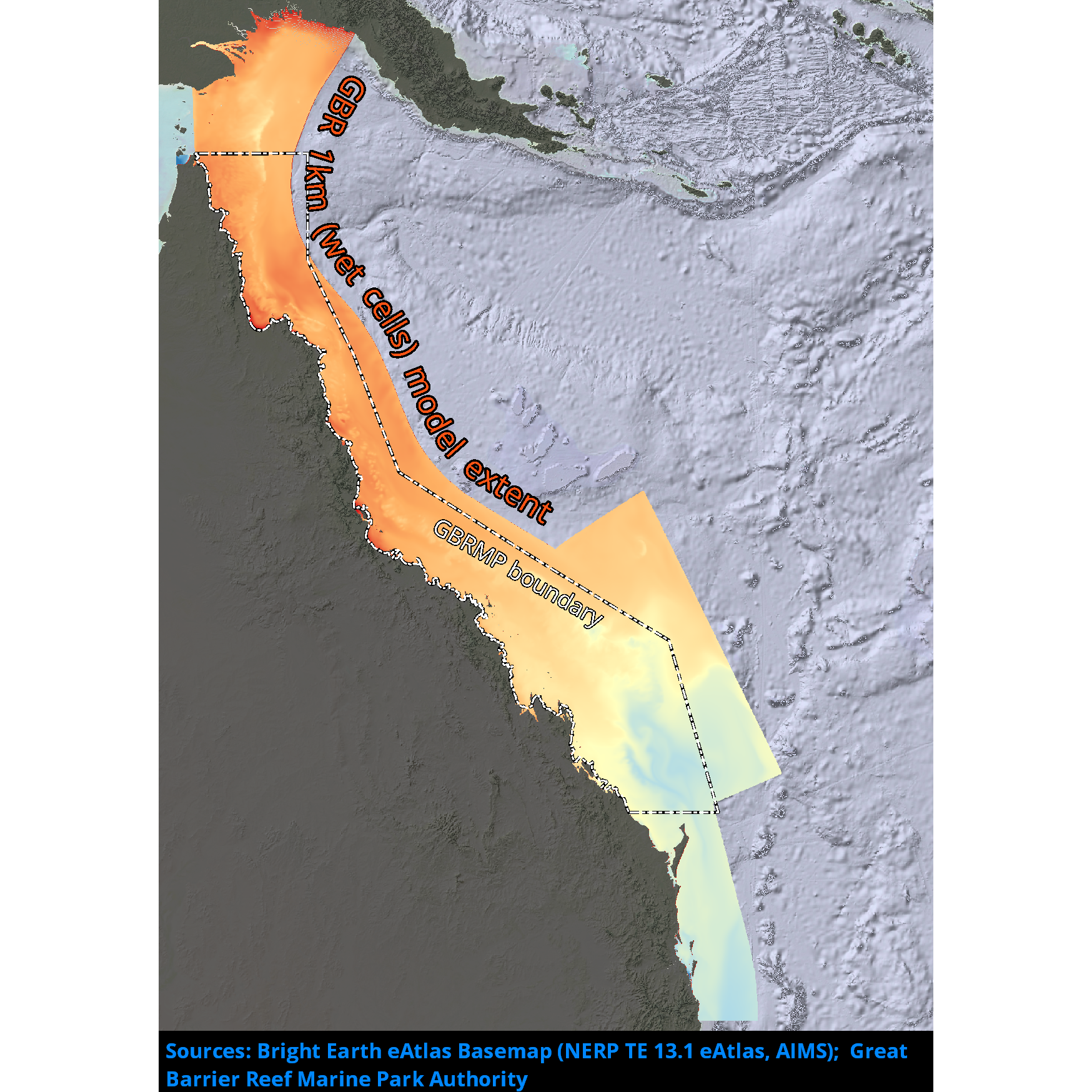
Results from version 2.0 of the 1km-resolution shelf-scale hydrodynamic model of the Great Barrier Reef (GBR1). This model is nested within version 2.0 of the 4km-resolution hydrodynamic model (GBR4) data at the ocean boundaries, uses the Bureau of Meteorology ACCESS-R model for surface atmospheric data and incorporates measured flow data from gauging stations at the river boundaries from QLD DNRM. This model configuration and associated results dataset may be referred to as "GBR1_H2p0" according to the eReefs simulation naming protocol. The model runs in near-real-time mode, updating daily.